| Ned Bryant : A Western GC Loop Adventure, or…Following Butchart’s Incredibly Terse Notes Out West | In August of 2014, my daughter and I hiked an 8-day loop in western GC, going down 209 Canyon, along the river, and then exiting via Trail Canyon. Along the way we successfully explored this beautiful and remote area of GCNP. The presentation will be a day by day review of the planning as well as showing a large number of photographs documenting our adventure, comparing it to Butchart’s notes, and including the surprise conclusion to our hike. |  |
| Lee Chandler : The Dome | In 2019, I climbed the following technical summits in the Grand Canyon: Isis, Zoroaster, O’neill Butte, Vishnu,, Mount Hayden, Brady Peak, The Dome and Buddha Temple. The Dome proved to be the most challenging and fulfilling of those climbs. It was climbed over three days in October by myself, Pernell Tomasi and Sean Peters. We were approximately the sixth to ninth party to ascend The Dome. The Dome is a prominent nine pitch climb in the Western Grand Canyon. It is accessed via the remote east Tuckup Trailhead, it was first climbed by George Bain and Glenn Rink in 1981. Over the years, more climbers have been turned around by the difficult climb than those who have succeeded. The climb lived up to its epic reputation in terms of its dangers and difficulties and provides a great story. Invaluable information will be presented in regards to the extensive logistics that went into planning this climb; a 24-mile backpack, three-day dry camp, and the carrying of nearly 100 pounds of climbing gear. Our party has climbed over 200 Grand Canyon summits and we all agreed that this summit represented the pinnacle of climbing in the Grand Canyon. I am excited and honored to be able to elaborate on the overall logistics, inherent dangers and motivations for climbing these obscure summits with a group of fellow Grand Canyon Enthusiasts. |  |
| Jamie Compos : Deconstructing the End to End Hike | Deconstructing the End to End Hike looks at the broad scope of hiking the length of the Canyon. With the latest data, this presentation highlights the increasing popularity of the endeavor, the development of its nuances, and the hike’s potential future. | 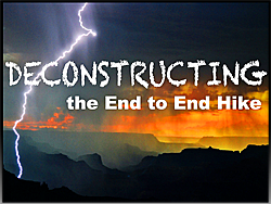 |
| Mark Egan : Solo Through Hike Experience | My presentation will be an overview of my solo traverse of the Grand Canyon that was completed in three section hikes. I will highlight some of the routing, weather, water, food, health, and gear challenges I faced. But, I will also share some of my favorite experiences I had along the way. My traverse totaled 526 miles over 47 days of hiking. The first section hike was conducted in the spring of 2016, it was 277 miles in length, and traversed from the western edge of Grand Canyon National Park to Kanab Point. The second section hike was conducted in the spring of 2018, it was 156 miles in length and traversed from Lees Ferry to Phantom Ranch. The final section hike completed the traverse in the fall of 2018, it was 128 miles in length, and traversed from Phantom Ranch to Kanab Point. | photo to come |
| Dennis Foster : Finding and Hiking the Old Horn Creek Trail | The first U.S.G.S. map of the Bright Angel Quadrangle was published in 1906. On this map, on the south side of the river, a trail is shown going down Horn Creek and then down to the river almost opposite 91 Mile Creek. Horn Creek is the first canyon west of Indian Garden and the popular Bright Angel Trail. After two failed attempts to locate and follow this old and abandoned trail – in 1981 and 2015 – I was finally able to cover most of it, and reach the river, on a day hike from my camp at Horn Creek. I did this hike with John Eastwood in late October of 2018. |  |
| Haley Johnson : The Zane Grey “Trail” | In the spring of 2018, we set off to follow in the footsteps of a favorite historic character. Zane Grey roped lions, attempted to hunt bears and explored much of Northern Arizona prior to the 1930’s. He successfully turned his “triplogs” into stories of the southwest. His characters were based off real people he met, or perhaps people he wished he could have met. Our “Zane Grey Trail” specifically followed routes taken when Grey visited Grand Canyon’s North Rim from Vermilion Cliffs to Jacob Lake and beyond. We linked together an estimated 150-mile route based on quotes from Grey’s books, notes, journals and letters home to his wife Dolly as well as help from Ed Meyer and Alan Pratt of Zane Grey West Society. This presentation will detail some of the route and findings while comparing Grey’s adventures to our own. |  |
| Bob Marley : 40th Anniversary of a River Corridor Walk from Diamond to Lees | By the end of the 1970s I connected a line from Lees Ferry to Lava Falls. It was riverside where possible, but necessarily leaving for lava intrusions, the Tapeats Platform, and Muav sections from Diamond to Eminence Break. I became intrigued by the thought of repeating my experiences in a continuous trip, adding the unknown section from Diamond to Lava, but thinking the most ambitious part might still be the ledges above and below Havasu Creek. Bob Cree had been exploring around Great Thumb with me and decided it was something he also wanted to do. Since we were taking primitive float gear for any necessary river crossings, our first self-imposed requirement was the trip had to be done upstream. The second was we would follow the river corridor as close to the Colorado as possible, making it an Inner Canyon through trek. We planned to start in late spring so the Canyon would warm up as we went but a health problem forced postponement until that fall. This left us facing oppressive daily heat until an early and major October cold snap arrived. We completed the trip in the planned 56 days and this year marks the 40th anniversary. |  |
| Scott Marley : Challenging the Basalt Cliffs | In March of 2018, Ned and Madeleine Bryant and I hiked from Lava Falls to Parashant along the river returning via the Esplanade. The challenge of this route was bypassing the basalt cliff around mile 183 blocking river side hiking. Few have hiked the bypass around this obstacle with the best route description we were able to find from Robert Benson’s notes that were written during the 1982 Steck-Benson through hike. We started the hike with heavy backpacks, descending the Lava Falls route to Tequila beach. The next day, hiking along the river was challenging with considerable brush and steep scree detours around basalt outcroppings. As a result, we made slow progress, arriving at our second night’s camp without enough time to complete the basalt cliff bypass route. The next day we were off to a good early start and were confident we would get back on our proposed itinerary. The bypass was complex in terms of route finding and rugged with basalt laden scree slopes; requiring a full day which was more time than we initially anticipated. The presentation will focus on the bypass route with some presentation of the return route via Parashant Canyon and Esplanade roads. |  |
| Kate McHugh : Wilderness Climbing in Grand Canyon | In December 2019, I completed a master’s thesis at Northern Arizona University that established monitoring indicators and a proposed monitoring protocol for wilderness climbing in the National Park Service based on law, policy, climbing management documents, research, and public comment. I pilot tested the field monitoring protocol in Grand Canyon and Joshua Tree National Parks between 2016 and 2019. I propose to talk in two parts (1) about my wilderness climbing research in a publicly approachable way, and (2) share about Grand Canyon climbing. In this research I monitored 11 fifth class climbing routes on ten Grand Canyon temples, as well as numerous other third and fourth class summits. Monitored routes include: Screaming Sky Crack, Zoroaster Temple; Southeast Face, Buddha Temple; North Cols and Buttress, Dana Butte; North Face, Monument Creek Pinnacle; The Doghouse, Angel’s Gate; East Face, O’Neill Butte; South Face, Mt. Hayden; Pegasus, Mt. Hayden; South Chimney, Brady Peak; Northeast Face, Sullivan Peak. The climbing monitoring expeditions ranged from 1-14 days, and collectively involved over one hundred miles of on- and off-trail travel. | 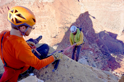 |
| Doug Nering : North and South Bass Trail Systems | Presentation will focus on both the North and South Bass trail systems connecting abandoned trails and historical sites to see on a hike. These include the ferry and tram sites, Mystic Spr, trails and Copper Cyn sites with tram to Hakatai, trail to Hakatai mines, and the irrigated garden works at Shinumo Camp. |  |
| Kern Nuttall: The Johnson Point Stock Trail at Lee’s Ferry | Among the hiking opportunities at Lee’s Ferry is the route up the northern edge of Johnson Point. Although not well known, the route was once a stock trail established by the ferryman Warren Johnson about 1880. Photographic evidence suggests Zane Grey climbed the trail in 1926. Largely obliterated, the route is now a moderately difficult scramble up a steep scree slope leading to the Point, a 400-foot vertical ascent taking about 20 minutes. Several clues mark the route, including a 4×4 inch post three feet high a hundred yards from the base of the slope. At the base of the cliff near the top are remnants of a barbwire gate. From the Point, turn west and north around the head of what some call Johnson Canyon. Part of the route follows a 1950s-era mining track which passes a uranium mine near the cliff edge. Descent back to the Paria River level is on a mining trail that drops through the Shinarump cliff. No crossing of the Paria is needed. The loop was completed December 1, 2019, in less than 4 hours. | photo to come |
| Tom Myers : Hard Not to Panic, Ain’t It? The Story of Ron Mitchell and the First Traverse of Marble Canyon | In December of 1974, Ron Mitchell completed the first documented traverse of Marble Canyon. It took 15 months and eleven attempts to accomplish the feat. Mitchell, then a Motorola engineer from Phoenix, is also the third person to have walked the length of Grand Canyon National Park following renown hikers Harvey Butchart and writer Colin Fletcher. In his endeavor to be the first through Marble Canyon, Mitchell occasionally found himself in dangerous situations. Such was the case in late May of 1974 when he and a companion ran out of water and were at serious risk of succumbing to intense heat. This incident was highlighted in 1976 in Arizona Magazine, as an article titled, Hard Not to Panic, Ain’t It? Fortunately, Mitchell and his companion survived and in the end, he accomplished something the legendary Butchart and Fletcher would not: a complete traverse of Marble Canyon. Also unlike Butchart and Fletcher, Mitchell’s accomplishments in Canyon hiking remain in relative obscurity and the man himself, an enigma. I would like to present a biographical sketch of Ron Mitchell and details of Marble Canyon traverse. I believe this narrative will appeal to Grand Canyon historians and hikers alike. |  |
| Rich Rudow : Traversing the Godscape | The Grand Canyon is far larger than most people realize. A traverse of the entire Grand Canyon below the rim is often broken up into thirds: Lee’s Ferry to Phantom Ranch, Phantom Ranch to Tuweep, and finally Tuweep to Pearce Ferry. The area west of Tuweep is by far the most mysterious and least known part of the Canyon to backpackers. The few early traverses tended to stay as close to the river as possible to mitigate unknown route and water fears while enhancing rescue prospects. Since those early traverses, the western canyon has been increasingly impacted by man’s activities in a dramatically negative way, and other routes further from the river away from man’s wrecking ball became interesting to explore. After spending more than 500 days exploring in the Canyon west of Tuweep alone, I’ve developed some informed opinions about traveling in this rarely visited part of the Park. In this talk I will contrast low route vs high route traverses while vividly illustrating the stunning and hidden beauty of the far west and why I call it the “Godscape.” | 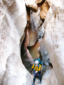 |
Same Old Trail Through New Eyes | Many hikers have completed the Hermit Trail / Tonto Trail / Bright Angel Trail Loop from the Hermit Trailhead to the Bright Angel Trailhead. Some have probably checked this one off their list and headed off to new adventures, content that they had seen what there is to see. Having now hiked this loop five times, my wife and I have discovered new and interesting things each time we do this backpack again. The most recent time we hiked this route we were passed in mid-day by a few trail runners who were doing the entire loop in a single day. I asked myself, “I wonder what they are missing?” The answer was, “Probably a lot”. An observant eye will see the route of an old telephone line from Indian Garden to Hermit Camp, remnants of telephone wire, the campsite of surveyors who were surveying a route for a cross-Canyon tramway in 1920, U.S. Geological Survey benchmarks, engraved names on the Canyon wall beside the trail, old engravings or painted signs on the rock showing elevation below the rim, fossil trackways, and the site of the runway for the only airplane landing and takeoff in the Canyon, among others. Hike length: 24 miles Time of year: Usually March |  |
| Larry Wieland : Grand Canyon Panorama Project | During the 90 minute lunch break Larry Wieland will do a presentation in the auditorium on the Grand Canyon Panorama Project. The project currently is a web site, project.gcpano.org, that presents panoramic 360° photography of locations along all the commonly hiked trails in the canyon, currently consisting of around 500 panoramas. A growing number of those panoramas include text narratives that interactively guide the viewer around the scene. After a brief overview of the project, Larry will lead a discussion about what direction the project might take in the future. One direction for the project would be to continue on its current path, focusing on expanding the collection of panoramas within the project and continued expansion of narratives. Another would be to open up the project as a general repository of trail descriptions and trip reports from the entire hiking community – with a way to search for trip reports within the project as if you were entering a Google search, and also by looking at a map which would plot the locations of reports. Trip reports and trail descriptions could either be hosted directly within the project, or if individual writers prefer the project could simply link to documents already located on other internet pages. I also envision a water conditions feature which would list all significant water sources along canyon trails where members could do real time posts of the water conditions and see a reverse chronological list of reports by water location. All these features would be free and open. Larry will also be inviting other community members to contribute to the project, through the contribution of their own panoramas, trip reports, and/or general photographs of the canyon. |  |
| Tracy Wyrick and Craig Schellbach : Schellbach Butte, A Family’s First Attempt | In October 2004, Craig Schellbach and Tim and Traci Wyrick hiked a 51.6 mile loop over 8-days, in a quest to fulfill a dream of climbing Schellbach Butte, named after Craig and Traci’s grandfather, Louis Schellbach III. It had been 10 years since Craig’s last Canyon hike. Tim had no hiking experience and Traci had 4 previous Canyon hikes. The trip began on the Widforss trail, to eyeball the butte from Widforss Point and determine future climbing routes. The approach was from the North Kaibab trail, then the alleged Cattle Route. After a time-consuming “newbie” error in crossing a steep Tonto drainage, we missed our campsite goal near Studervant Point. Low on daylight and water the next day, we had to turn back for Phantom Creek. Disappointed, but not done, we climbed Cheops-Isis saddle the following day. With our 9lb 8mmX60m rope, we rappelled into Phantom creek the next morning where we sloshed and swam our way to the North Kaibab trail. The following morning we hiked to the river to investigate where our maternal grandparents, Dean and Edna Tidball had lived while Dean was the USGS hydrographer there during the 50’s. On to Cottonwood campground that night, and exiting via North Kaibab the next morning. | 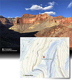 |